Today we hit the sights. The day was partly cloudy with temperatures warm enough that I found a long sleeve shirt adequate while in the sun and walking. When it was drizzling rain, and we were in the shade/wind, a jacket felt really good.
The following photos are from a drive we took down south of the RV park.
It wasn't to cold for the hearty soul that is the speck in the center of this photo. He was standing on a "surf board" and using a long handled paddle to propel himself out into the bay and then he would "ride" a wave back in toward shore.
We saw quite a few seals and sea lions. The sandy area in front of the large rock was covered with seals/sea lions. They were supposed to have pups but even the smallest ones looked pretty good sized.
We pulled of the road and decided to take a hike in the drizzle.
We wanted to go down and look at this cove.
Climbing back out. Can you find Kathy waving at you?
Looking down on the cove from the trail above.
Interesting rock formations
The same rocks from a point further along the trail.
The southern most rock in the above photos, the one on the left, is on the right edge of the photo below. The trail from which I took the first picture of the rocks is on the bluff in the center of this photo.
Next we drove down by one of harbors that are around the bay. The two photos below are just to give you an idea of the huge number of boats in the bay.
We stopped at Walmart to pick up a prescription and I had to take a photo of the raindrops falling on the windshield. Note the reflection form the sun in the bottom corner of the windshield. It was drizzling rain and yet the sun was brilliant. Small rain clouds would move in, drop some light rain, and move out. Often the clouds were so small that they didn't block much of the sun.
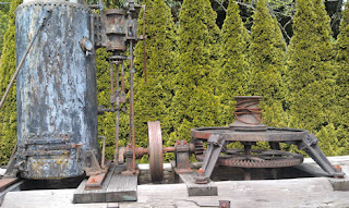
Next we stopped at a museum. This is a photo of a "steam spool donkey". This one was built in 1902 and was in use from 1905-1950. Large logs were pulled to a loading site using the cable wrapped around the spool. After a log was pulled to the site the cable was hooked to a horse and the horse drug the cable back out to the next log. Once an area was logged the donkey was "sledded" to a new location.We then drove north out of town, over the Coos Bay Bridge, it is actually named the Conde McCullough bridge, after its designer. It was completed in 1936, has a main span of 793' and provides 150' of clearance for ships. The total length of the entire bridge is a little over a mile. See a better photos at
http://en.wikipedia.org/wiki/Conde_McCullough_Memorial_Bridge and
http://www.bridgemeister.com/pic.php?pid=117
Below is a lousy photo I took while Kathy was driving across the bridge. I will try to get a better one tomorrow when we cross it in the RV. The arched cross section is cool.
There is a large park in the center of Coos Bay, with 3 lakes. A wild guess would be that the total surface area of the the three lakes is 20-30 acres. There are very nice asphalt pathway all around the park. We took an hour long walk along some of them. Fortunately Kathy's sense of direction is much better than mine or the walk would have been much longer (I think I could get lost in Walmart <grin>).
After that we called it a day and headed home.
Tomorrow we plan to head for Rockaway Beach, OR. It is on the coast, about 50 miles south of the Oregon/Washington border.
Hope this makes sense. I wasn't sleeping well so I got up and wrote this, and did some other "computer stuff", in the wee hours. Now that it is daylight sleepiness is setting in. Good think Kathy doesn't mind driving, and that navigating won't be much of a problem since we just get on 101 and head north.


No comments:
Post a Comment