Wednesday, September 14, 2022

Tuesday, September 13th - Checked out Keokuk, Iowa

A friend of ours from Florida sent me the link below. It is an article about the Dallas City house I posted about.

https://www.mississippivalleypublishing.com/daily_democrat/renovated-castle-is-part-of-dallas-city-history/article_1558f652-7599-11e8-a779-374b12832b8f.html?utm_medium=social&utm_source=email&utm_campaign=user-share 

Good weather again today. Last nights low was 52. Todays high was a sunny 81, to hot but tolerable. We are not looking forward to arriving back in Centertown to 90 degree weather. Last May/June, when we scheduled Doctors appointments for September 20th, we didn't imagine the temperatures would still be in the 90's. Live and learn. Next year I won't be scheduling any summer Doctors appointments between early June and early October.

Hamilton, IL & Keokuk, IA are 12-13 miles downriver from Nauvoo. I wanted to see the lock and dam at Keokuk so we drove down today.

The Mississippi is almost a mile wide in this area. Hugh Cooper was the Engineer who designed and managed the construction of the Keokuk dam and power plant. The dam flooded a lot of low ground both sides of the Mississippi. This area is also called Cooper Lake. I was surprised to learn that the Mississippi is very shallow. The Corps of Engineers are tasked with  keeping a 9' deep navigation channel dredged.

Some areas near the shore are full of "lilies" that extend hundreds of yards out into the river/lake.

We had an excellent lunch at the Hamilton Family Cafe. Bowls, not cups, of soup came with the meals. The total bill for my excellent hot beef sandwich and Kathy's good chicken and swiss sandwich was $18.57. Kathy wants to drive back down there for breakfast tomorrow morning. A 6 oz steak and eggs for less than $11.

Are you ready to be bored? The Engineer in me came out looking at bridges, locks and dams.

The story about the Keokuk/Hamilton dam, power plant and lock is interesting. One of the most amazing things is that it was conceived and built as a private enterprise. As part of the deal to get federal government approval to build the dam across the Mississippi they had to agree to build the lock and give it to the government. How different things are today. In Jefferson City a group wants to build a barge terminal, but only if the government forces taxpayers to foot the bill.

The vantage point to see the locks is the upper deck of a bridge across the river. The bridge was opened to traffic in 1916. The lower deck of the swing bridge still carries rail traffic. After a new highway bridge was opened in 1985 the upper deck was closed to vehicles. The Iowa side is used as an observation platform.

Walking out onto the bridge, past the edge of the old brick street.
The street came in from the north while rail traffic came in from the south.

River traffic has the right of way so the swing bridge only closes when a train is ready to cross.
The white shack is set off to the side of tracks, directly above the swing mechanism.
There is more information about the bridge at:

https://en.wikipedia.org/wiki/Keokuk_Rail_Bridge 

https://historicbridges.org/bridges/browser/?bridgebrowser=iowa/keokuk/

A tug was leaving the lock when we arrived. On the way back to Nauvoo we saw a tug with barges headed upstream. I thought there would be more traffic on the river.


The lock, dam and hydro electric plant.


If you are interested you can read more at: 


https://www.asce.org/about-civil-engineering/history-and-heritage/historic-landmarks/keokuk-dam-and-power-plant-project/

https://www.ameren.com/missouri/company/environment-and-sustainability/hydroelectric/keokuk 

God is good. I pray that He blesses you and yours.


Monday, September 12, 2022

Monday, September 12th - Poking Around Nauvoo

 Weather - another beautiful day. Last nights low was in the mid 50's and todays high was a breezy, mostly sunny 74.

Some more campground photos. From the far edge of the campground you can see the river. The view would be awesome if some of these trees were removed.

The "pine forest" is close to our site. It reminds us of MI's UP.

Downtown Nauvoo. The blue building on the left and the brick builing in the photo below, are hotels. We stayed overnight here, during a weekend get-a-way, sometime in the late 80's. We thing we stayed in the blue hotel.


When travelling after Labor Day you miss out on some novel entertainment, like the Wild Axe Company.
We could have gotten some axe throwing lessons but alas, it was closed.


The new Mormon Temple completed in 2002. It is built on the site of the original Temple that was destroyed in the 1840's.


We spent several hours poking around Nauvoo. We had lunch at the only restaurant that was open. There really isn't much to the town, other than all the tourist who come to see the "old city" down by the river. The two non-Mormon museums were supposed to open at 1 PM. No one showed up to open either of them. The city opens the door to some of our nations dark past.

In 1831 Joseph Smith proclaimed that God had designated western Missouri as the place where “Zion” would be gathered in anticipation of Christ’s second coming. This led to a steady stream of converts who wanted to get established in the future “Zion”.

Many of the people already in Missouri discriminated against the Mormons. Violence led to the 1838 Missouri/Mormon War. Missouri’s Governor issued Executive Order 44 ordering Mormons to leave Missouri or be killed. Joseph Smith and around 10,000 Mormons escaped Missouri and some of them established the new settlement that became Nauvoo, Illinois. They dug a three quarter mile long, 8’ deep, 12’ wide, canal to drain 800 acres of mosquito infested swamp into the Mississippi. By 1844 the population of Nauvoo had skyrocketed to over 10,000.

It appears to me that people jealous of the Mormon’s success once again started persecuting them. Smith ordered the destruction of an anti-Smith printing press. The Illinois Governor promised Smith protection if he would turn himself in and stand trial for the destruction of the press. Smith and his brother who also had been arrested, were murdered 3 days later, while in jail. The result was a series of running battles between Mormon’s and non-Mormons. Under pressure from the Illinois Governor Brigham Young, the new leader, agreed to abandon Nauvoo and leave Illinois in the spring of 1846.

God is good. I pray that He blesses you and yours.


Sunday, September 11, 2022

Sunday, September 11 - A Day of Remembrance - This day in 2001 2,977 People Murdered on American Soil by Islamic Terrorists

 It started raining a little before 10PM last night, and didn't stop until 9AM today. It was a good soaker rain. There was very little standing water when the rain stopped.

Last nights low was 57. Todays high was a breezy, mostly sunny 74. Lovely weather.

We did some driving around and looking today. We saw some interesting buildings in Lomax and Dallas City when we drove through yesterday but I didn't take any photos. We went back this morning and checked them out before crossing the Mississippi and checking out Fort Madison, Iowa.


You just don't get to see stuff like this while travelling the Interstates.

The Pink, a bar in Lomax, IL

We weren't sure what this building in Dallas City, IL might have been. The surrounding structure seemed like it might have been a school at one time, but the main old building seemed way to ornate for that. It looked like everything was being torn down. I wished I would have been a little more bold while I was there and looked for a way to get in an peek at the interior.
The cornerstone said Oct. 31, A.D. 1895


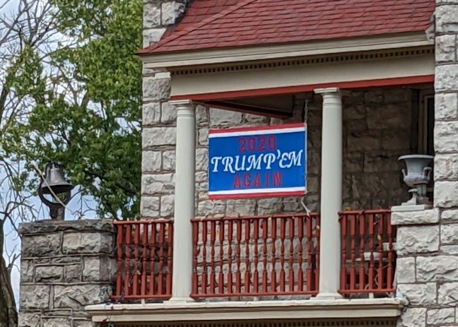
A  home in Dallas City. More on the sign on the balcony, at the left side of the building, later.

We still see Trump signs as we travel, but no Biden signs.
The Mississippi River at Dallas City. The land you see on the other side of the water is an island. The grain elevator is on the other side of the river. You can see the island on the above map photo.

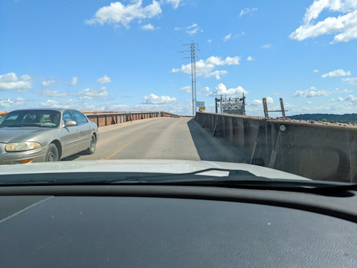
Crossing the Fort Madison Toll Bridge was interesting. It is a double decker swing bridge. There are two lanes of highway traffic on the top deck and two sets of rails on the lower deck. The highway deck is reasonably busy but the rail deck is very busy, train after train. The bridge and approaches total about a mile in length. It has a 525' swing span, for barge traffic. (I just read that the swing span is still operational. It "swings" about 2,000 times a year. I may have to get sit and watch it tomorrow and Tuesday.)  It was opened in 1927.

When entering the approaches you are warned that the maximum width is 8' (most Class A motorhomes are 8'4" to 8'6" wide, not counting the mirrors) height 14'4", maximum length 60' and maximum gross weight is 16,000# (our coach has a GVWR of 35,000#). No semi traffic is allowed on the bridge.

When we were on the approach, heading west from the IL side, 5 engines on a train passed us going east. When we got off the bridge on the Iowa side the end of the train has still not reached the bridge.

There is a toll collection booth on the bridge but today it was unmanned. A sign said "No Tolls" The bridge is owned by the Burlington Northern Santa Fe Railway.

From the Fort Madison side.
The approaches to the main span seemed very narrow.

Once you were on the main span the bridge seemed wider.


Fort Madison marina.
 

We drove up and down several streets looking at houses, and the business district. The we had lunch at the Chuong Garden restaurant in Fort Madison. The food was good and very reasonably priced. After lunch we went to Old Fort Madison. Kathy sat in the shade on a bench out by the river while I toured the fort.
There was a reenactment going on right after we arrived. There were 5 guys dressed up as soldiers and maybe 7 dressed up as the French or British attackers.
A canon occasionally fired from the blockhouse on the right.
I have only fired a flintlock once so I'm not a judge of the actors techniques. I will say if all the misfires are any indication of real life back in the early 1800's I don't understand why a few Indians with bows and arrows didn't wipe out the entire US Army. I watched misfire after misfire. These guys could have run up and stabbed the opposing forces before they reloaded and fired.
As I was touring the fort I did have a good conversation about the history of the area, with one of the reenactors. 
I don't know if you can make it out in the photo below but there are 4(?) engines pulling a train across the bridge eastbound. The engines are off the main span and on the Illinois side.
I turned around and took a photo of the end of the train as it was still passing through Fort Madison.

I think there are only 3 RV's in the campground tonight. It is a quite place.

God is good. I pray that He blesses you and yours.


Saturday, September 10, 2022

Saturday, September 10th - Another Travel Day

 Today we travelled from Hickory Hills Campground in Secor, IL to Camp Nauvoo in Nauvoo, IL. More on that later. First some more photos from Hickory Hills.

There are dozens of golf carts at the campground. During a walk this morning I saw several campsites that had multiple golf carts. The campground is pretty good sized, but its not to big to walk between the furthest spaced campgrounds.


The two photos below are of Campsite #13, the one mentioned in the For Sale flyer, asking price $22,500. Everything looked to be in good shape. The camper appears to be about the same size as the one we had.
I bet the screened porch gets a lot of use.
Further along my morning walk I went down by a small lake and looked back up at several sites that looked out over the lake.

Up near the shore the water in the lake looked crystal clear,  The photo below is of the campsites along the other shore.

Todays trip was 140 miles. Our Garmin GPS wanted to route us up through Galesburg, IL, which was ridiculous. I also didn't like the route shown my Google Maps. It is easier to tweak the Google Maps route and I did so. Our Garmin unit is for RV's and supposedly gives you the best route for an RV. It seems to heavily favor keeping you on Interstates, even if the route is longer and takes more time.

We stayed on US24 to Peoria, took I74 & I474 around/through Peoria and then took IL116 out of Peoria. To get from IL116 to IL94 we (Kathy) drove down 12 miles of country road. The pavement surfaces along the entire route varied from 3 miles of the county road signed as being bumpy (but not horrible) to excellent. Traffic was minimal. We have driven MANY 12 mile stretches of Interstate that were FAR worse that the 12 miles of county road we drove on today. The route we took saved us over 20 miles and was almost 30 minutes quicker than Garmin's route.

Parked at Camp Nauvoo. Not a lot of room between campsites but there is no one on either side of us. I think this is the first campground during the trip were we had a nice level concrete pad. Full hook up, 50 amp, sites, $32/night.
Some of these "tiny houses" are supposed to sleep up to six. They rent for $110/night. 
There is supposed to be a washer, $1.50/load, in the ladies shower area (very sexist) and a dryer that is free. There is some playground equipment and area around the campground for nice walks.

To get here you drive through the Nauvoo State Park. It also has some campsites. The road through the park needs some tree trimming. Low hanging branches drug across our roof (nothing serious) several times.

Weather was okay, but to warm/humid for us. The high was 84 and it was somewhat humid. It just started to rain, 9:40 PM. The rain is to continue through most of the night and cool things down. From the looks of the grass they need rain.

We did see quite a few acres where the corn has already been picked/harvested. That was a first.

God is good. I pray that He blesses you and yours.


Friday, September 9, 2022

Thursday & Friday, September 8th & 9th - Travelling Day

 Thursday - Mom treated Kathy and I to lunch at one of the Mexican restaurants in Coldwater. The food was good, the lunch portions were huge and the prices were great. Kathy looks tired, she probably was.


The water bladder I ordered from Amazon came yesterday. I knew we were getting low on water so I "tested" it. I went down to my brothers, unfolded the bladder on top of the Flex, and filled it up. Back at Mom's I parked by the coach and used a hose to connect the bladder to the coach water tank. Actually I did this prior to our going to Coldwater for lunch. While in Coldwater I bought a small, drill driven pump at Home Depot. When we arrived back at the coach 15-20 gallons had gravity drained into the coach tank. I hooked up the pump and quickly transferred the remainder. Gravity works, if you have all day, but the pump is the way to go. I refolded the bladder and it is back in its 10x13 shipping envelope.


Later in the afternoon Mom and I went back to Coldwater to visit my Uncle Don and his wife Jan. Don was one of my Dad's brothers-in-law. He was married to my Aunt Norma. She died at a young age, late 30's, early 40's, after they had moved to Texas. After he retired he returned to the Coldwater area. He married Jan many years ago.

Friday - We left Mom's around 9:30 this morning. To get to Secor, IL both Google Maps and my Garmin GPS route you down the Indiana Toll Road, through the south side of Chicago. We didn't want to do that. We took I69 down to US24 in Fort Wayne and stayed on US24 all the way to the campground, 274 miles. I remain convinced that pavement surfaces on US highways are FAR, FAR better than the Interstates. It may take a little longer, but it adds interest to drive through some small towns along the way. There are bypasses around the larger towns. We even drove on a small section signed as part of the original Route 66.

We stopped at the parking lot for a "decommissioned" school in Reynolds, IN and ate lunch. The building is now owned, and used, by the town. There is a church in one end of it.


There are lots of windmills in the area. If you look closely you may be able to pick out a blade of one just left of the sign and another just left of the tree in the center of the photo.

Then it was on to Hickory Hill Campground. There are LOTS of park type units here. There was a sign on the outside of the office, "Site 13 For Sale, Asking $22,500". I didn't walk over to see it, it was quite a ways to it. Photos on the flyer indicated that you were buying a site and a camper of some type.

Sites are fairly closely spaced, but I don't think that is a problem for the more permanent campers. As I walked around the campground I ran across several on going "parties" where chairs were even out in the roadway.
A 60ish lady from North Carolina owns the coach on the left side of the above photo. She is on her way back from a month in Alaska. She and her husband signed up for the trip before COVID struck. He died unexpectedly and she decided to go anyway. She picked up a cousin in MN. They joined up with 25 other coaches in Coeur d' Alene, ID and headed north. Coeur d' Alene to Denali Park is 2,400 miles, several hundred miles further than we have driven our coach during this trip.. The 25 coaches didn't necessarily travel together in a caravan but they all stayed in the same campgrounds every night. 

While we were sitting outside tonight the guy across the street was working on a shelter for his 5th wheel unit.
Playground equipment, a pool (closed for the season), a putt putt golf course, shuffle board courts, horse shoe pits, etc available for entertainment.

I'm not sure what there might be to do/see around here. Right now I think the place is great for an overnight stay, $40 for a full hookup. I would stay here again if we needed to overnight in the area.

Kathy is taking full advantage of the full hookup. She has already done 4 loads of laundry and still has one to go.

Weather was a little toasty today, high mid 80's, its still 70 at 9PM. We turned the AC on when we arrived and probably will let it run all night. Sure not looking forward to the mid/high 80's forecast for our return to Centertown. We both have Doctor's appointments on the 20th or we might consider heading north instead of south when we hit the Mississippi.

God is good. I pray that He blesses you and yours.